File:PalestineFourMaps.png
Jump to navigation
Jump to search


Size of this preview: 800 × 537 pixels. Other resolutions: 320 × 215 pixels | 1,100 × 738 pixels.
Original file (1,100 × 738 pixels, file size: 513 KB, MIME type: image/png)
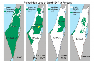
Four maps illustrating Palestinian loss of land to the state of Israel. Source: If Americans Knew
File history
Click on a date/time to view the file as it appeared at that time.
| Date/Time | Thumbnail | Dimensions | User | Comment | |
|---|---|---|---|---|---|
| current | 08:56, 26 July 2015 | | 1,100 × 738 (513 KB) | Peter (talk | contribs) | Four maps illustrating Palestinian loss of land to the state of Israel. Source: If Americans Knew |
- You cannot overwrite this file.
File usage
The following page uses this file: